Flutter Gems is a curated list of 7000+ useful Dart & Flutter packages that are categorized based on functionality.
Top Flutter Geolocation Utilities packages
Last updated: October 19, 2025
The complete list of Dart and Flutter packages that provide Map and Geolocation Utilities is provided below.
geocoding
👍 1.33K ⬇️ 425.5K
Dart 3 compatibleMaintenance Status: Good


A Flutter Geocoding plugin which provides easy geocoding and reverse-geocoding features.
flutter_polyline_points
👍 641 ⬇️ 66.5K
Dart 3 compatibleMaintenance Status: Good


A flutter package to get polyline points by either passing the coordinates or google encoded polyline string
latlong2
👍 366 ⬇️ 350.6K
Dart 3 compatibleMaintenance Status: Average

Lightweight library for common latitude and longitude calculation
maps_toolkit
👍 379 ⬇️ 55K
Dart 3 compatibleMaintenance Status: Good
Maps toolkit - geo-measurements utils - area of polygon, distance between point, heading and offset between points (port of SphericalUtil, PolyUtil from 'android-maps-utils').
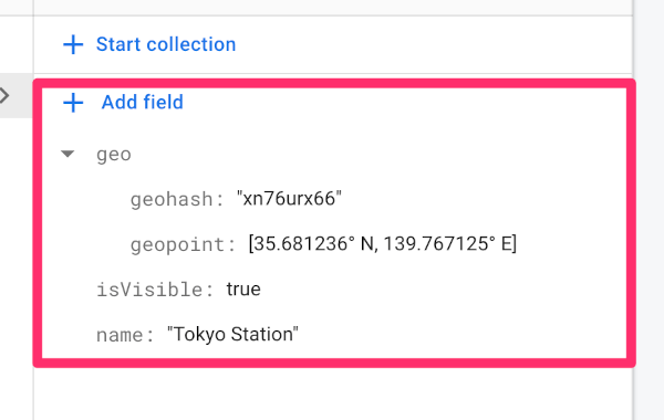
geoflutterfire
👍 395 ⬇️ 356
Dart 3 compatibleMaintenance Status: Poor
GeoFlutterFire is an open-source library that allows you to store and query firestore documents based on their geographic location.
proj4dart
👍 40 ⬇️ 251.8K
Dart 3 compatibleMaintenance Status: Poor
Proj4dart is a Dart library to transform point coordinates from one coordinate system to another, including datum transformations (Dart version of proj4js/proj4js).
mgrs_dart
👍 4 ⬇️ 255K
Dart 3 compatibleMaintenance Status: Poor
Utility for converting between WGS84 lat/lng and MGRS coordinates (Dart version of proj4js/mgrs).
wkt_parser
👍 2 ⬇️ 255.1K
Dart 3 compatibleMaintenance Status: Poor
Wkt-parser is a Dart version of proj4js/wkt-parser. With wkt-parser you can parse a WKT projection string (OGC, ESRI) into json that proj4dart can consume.
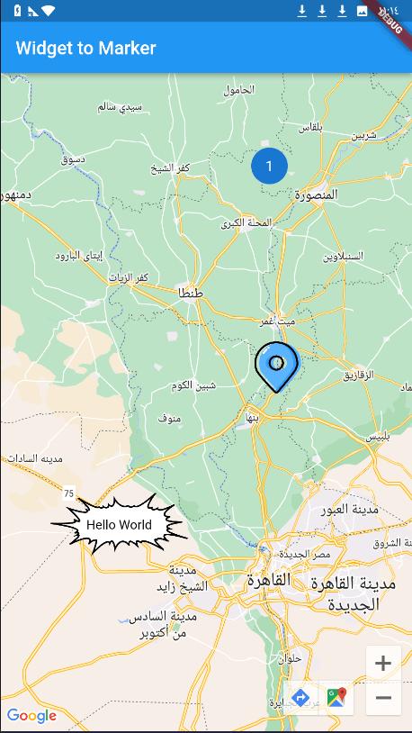
widget_to_marker
👍 127 ⬇️ 28.9K
Dart 3 compatibleMaintenance Status: Average
A package to convert any Flutter Widget to BitmapDescriptor which can be used in google_maps_flutter icon marker.
geocode
👍 124 ⬇️ 7.8K
Dart 3 compatibleMaintenance Status: Poor
Package to make Geocode requests. It exposes two methods to translate coordinates into locations and addresses into coordinates.
geoflutterfire2
👍 119 ⬇️ 7.6K
Dart 3 compatibleMaintenance Status: Poor
GeoFlutterFire2 is an open-source library that allows you to store and query firestore documents based on their geographic location.
flutter_geofire
👍 103 ⬇️ 687
Dart 3 compatibleMaintenance Status: Good
A Flutter plugin to get the realtime updates of places nearby. GeoFire is an open-source library for that allows you to store and query a set of keys based on their geographic location.
turf
👍 49 ⬇️ 64.9K
Dart 3 compatibleMaintenance Status: Average
A turf.js-like geospatial analysis library working with GeoJSON, written in pure Dart.
geoflutterfire_plus
👍 79 ⬇️ 6.1K
Dart 3 compatibleMaintenance Status: Good
geoflutterfire_plus enables your flutter app to store and query cloud firestore documents based on their geographic location.
search_cep
👍 65 ⬇️ 21.2K
Dart 3 compatibleMaintenance Status: Poor
Package to facilitate and expedite communication with the via_cep API and obtain information about zip codes and locations throughout Brazil
custom_marker
👍 80 ⬇️ 1.1K
Dart 3 compatibleMaintenance Status: Poor
A package to convert Widget, Local image, Netwok image, Svg file to BitmapDescriptor which can be used in google_maps_flutter icon marker.
geodesy
👍 62 ⬇️ 22.1K
Dart 3 compatibleMaintenance Status: Average
A Dart library for geodesic and trigonometric calculations working with points and paths
carp_background_location
👍 74 ⬇️ 136
Dart 3 compatibleMaintenance Status: Poor
A location plugin that works in the background. Supports Android and iOS
gpx
👍 66 ⬇️ 8.7K
Dart 3 compatibleMaintenance Status: Good
Package for load, manipulate, and save GPS data in GPX format (a light-weight XML data format for the interchange of GPS data - waypoints, routes, and tracks).
dart_geohash
👍 50 ⬇️ 22K
Dart 3 compatibleMaintenance Status: Average
A simple encode, decode, and neighbor finder for longitude/latitude and geohash.
google_polyline_algorithm
👍 54 ⬇️ 16.5K
Dart 3 compatibleMaintenance Status: Poor
Dart implementation of Googles Polyline Encoding lossy compression Algorithm.
geojson
👍 62 ⬇️ 1.5K
Dart 3 compatibleMaintenance Status: Poor
Utilities to work with geojson data. Parser with a reactive api, search and geofencing
easy_geofencing
👍 62 ⬇️ 78
Dart 3 compatibleMaintenance Status: Poor
This is a dart package which give the best & optimized geofence background services features for both android & ios.
trust_location
👍 57 ⬇️ 3.6K
Dart 3 compatibleMaintenance Status: Poor
A Flutter plugin for detecting mock location on Android device.
amap_flutter_location
👍 59 ⬇️ 799
Dart 3 compatibleMaintenance Status: Poor
Gaode positioning SDK Flutter plug-in
google_directions_api
👍 56 ⬇️ 1.1K
Dart 3 compatibleMaintenance Status: Average
The Directions API is a service that calculates directions between locations. You can search for directions for several modes of transportation.
geocoder2
👍 52 ⬇️ 2.3K
Dart 3 compatibleMaintenance Status: Poor
Forward and reverse geocoding is Easy Now.
fl_location
👍 48 ⬇️ 5.9K
Dart 3 compatibleMaintenance Status: Good
A plugin that can access the location services of each platform and collect device location data.
geotypes
👍 2 ⬇️ 64.7K
Dart 3 compatibleMaintenance Status: Average
A lightweight library for GeoJSON data types available dart and flutter.
turf_equality
👍 2 ⬇️ 64.7K
Dart 3 compatibleMaintenance Status: Average
Comparison of two GeoJSON objects, based on the turf pub-package
yandex_geocoder
👍 51 ⬇️ 601
Dart 3 compatibleMaintenance Status: Average
API to translate geographic coordinates into an address and vice versa
daylight
👍 44 ⬇️ 5.8K
Dart 3 compatibleMaintenance Status: Average
Get the sunset and sunrise times for a geolocation without having to access any remote api.
google_geocoding_api
👍 39 ⬇️ 6.8K
Dart 3 compatibleMaintenance Status: Average
This Package implement Google Geocoding API with default and reverse geosearch
latlng
👍 36 ⬇️ 9.9K
Dart 3 compatibleMaintenance Status: Average
GeoJSON, Geodesy and Geographical calculations for Dart. Provides LatLong and Mercator projection (EPSG4326).
flutter_map_dragmarker
👍 32 ⬇️ 12.7K
Dart 3 compatibleMaintenance Status: Good
Dragmarker class for flutter_map
detect_fake_location
👍 38 ⬇️ 2.2K
Dart 3 compatibleMaintenance Status: Good
A Flutter plugin for detecting if location is being simulated or faked
background_geolocation_firebase
👍 37 ⬇️ 129
Dart 3 compatibleMaintenance Status: Average
A Firebase adapter for the flutter_background_geolocation plugin. Automatically syncs recorded locations to your Firestore database.
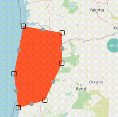
flutter_map_line_editor
👍 32 ⬇️ 6.6K
Dart 3 compatibleMaintenance Status: Good
A basic Line and Polygon editor for `flutter_map` using drag markers
flutter_map_arcgis
👍 36 ⬇️ 213
Dart 3 compatibleMaintenance Status: Average
Arcgis plugin for flutter map. Features Support unique render, ontap event, ontap with atttributes, geometry types (point, polgyon, polylin)
flutter_map_math
👍 31 ⬇️ 4.9K
Dart 3 compatibleMaintenance Status: Good
Map realated calculations in one place. Like finding distance, mid point, bearing angle of two points.And finding destination point.Also convert degrees to radians and vice-versa
geofence_foreground_service
👍 34 ⬇️ 727
Dart 3 compatibleMaintenance Status: Good
A Flutter project that creates a foreground service to handle geofencing.
nominatim_flutter
👍 32 ⬇️ 3K
Dart 3 compatibleMaintenance Status: Good
The Nominatim Flutter Plugin enables smooth Nominatim service integration for reverse geocoding, place searches, status checks, and lookups in Flutter.
geobase
👍 31 ⬇️ 3.6K
Dart 3 compatibleMaintenance Status: Good
Geospatial data, geometry, geodesy, projections, tiling schemes, and vector formats (GeoJSON, WKT, WKB).
native_geofence
👍 32 ⬇️ 1.8K
Dart 3 compatibleMaintenance Status: Good
Battery efficient Flutter Geofencing that uses native iOS and Android APIs.
georange
👍 33 ⬇️ 184
Dart 3 compatibleMaintenance Status: Poor
A package that helps with encoding geohashes, decoding geohashes,calculating distance between 2 points and generating latitudinal and longitudinal ranges as geohashes to help with the querying of databases (Tested on Firestore Only).
osm_nominatim
👍 31 ⬇️ 2.6K
Dart 3 compatibleMaintenance Status: Good
A library to perform OSM Nominatim searches also supporting reverse searches
flutter_bmflocation
👍 31 ⬇️ 668
Dart 3 compatibleMaintenance Status: Good
BaiduMapLocation plugin for flutter. This plugin provides a cross-platform (iOS, Android) API to request location.
mobility_features
👍 31 ⬇️ 411
Dart 3 compatibleMaintenance Status: Average
Calculation of real-time mobility features like places, stops, and home stay
geocoder_buddy
👍 29 ⬇️ 367
Dart 3 compatibleMaintenance Status: Poor
Forward, Reverse geocoding and Search Address without any apikey.
lat_lng_to_timezone
👍 25 ⬇️ 5.5K
Dart 3 compatibleMaintenance Status: Poor
Lat/long to timezone mapper in Dart. Does not require web services or data files
routing_client_dart
👍 24 ⬇️ 6.3K
Dart 3 compatibleMaintenance Status: Good
Dart Package for Routing Client Api ( support OSRM/Valhalla project )
flutter_image_map
👍 26 ⬇️ 2.4K
Dart 3 compatibleMaintenance Status: Average
Image map, create areas with customizable colors on an image and response to clicking/touching. Just like what we have in html.
flutter_map_geojson
👍 25 ⬇️ 2.7K
Dart 3 compatibleMaintenance Status: Average
This package parses GeoJson formatted spatial data and creates arrays of Flutter Map objects using default or custom defined create functions.
animated_marker
👍 26 ⬇️ 840
Dart 3 compatibleMaintenance Status: Good
The AnimatedMarker widget is a Dart class that animates the movement of markers on a Google map.
osrm
👍 26 ⬇️ 235
Dart 3 compatibleMaintenance Status: Average
Open Source Routing Machine (OSRM) client for Dart.
geofence_flutter
👍 25 ⬇️ 61
Dart 3 compatibleMaintenance Status: Poor
Flutter geofencing plugin for flutter application (android and ios).
geocoder_offline
👍 24 ⬇️ 78
Dart 3 compatibleMaintenance Status: Poor
Package for super-fast offline reverse geocoding. Search is done in the file of your choice.
google_maps_directions
👍 23 ⬇️ 496
Dart 3 compatibleMaintenance Status: Poor
Calculate distances, durations & Get shortest route/leg between two points.
georouter
👍 22 ⬇️ 7
Dart 3 compatibleMaintenance Status: Poor
A package for getting directions between points using the Open Source Routing Machine (OSRM) API. Supports multiple travel modes, including driving, walking, cycling, and transit.
compassx
👍 19 ⬇️ 1.4K
Dart 3 compatibleMaintenance Status: Average
Flutter compass plugin offering true heading, accuracy, and calibration needs.
raw_gnss
👍 19 ⬇️ 15
Dart 3 compatibleMaintenance Status: Poor
Fetch Raw GNSS Data - GNSS Measurement Events, Navigation Messages, and Status Events
geofencing_api
👍 17 ⬇️ 691
Dart 3 compatibleMaintenance Status: Good
This plugin is used to implement circular and polygon geofencing service.
gmaps_by_road_distance_calculator
👍 13 ⬇️ 257
Dart 3 compatibleMaintenance Status: Good
This is a Package to calculate the by-road distance from one point to another in map.
air_quality
👍 12 ⬇️ 1.3K
Dart 3 compatibleMaintenance Status: Good
Air quality index from the World's Air Quality Index (WAQI) service.
carp_context_package
👍 12 ⬇️ 420
Dart 3 compatibleMaintenance Status: Good
CARP context sampling package. Samples location, mobility, activity, weather, air-quality, and geofence.
geo
👍 9 ⬇️ 579
Dart 3 compatibleMaintenance Status: Poor
A set of functions and types usable in a geographic's context
webview_location
👍 8 ⬇️ 44
Dart 3 compatibleMaintenance Status: Average
A Simple flutter package designed to display Google Maps locations by place name in a WebView for both Android and iOS platforms.
geodata
👍 5 ⬇️ 238
Dart 3 compatibleMaintenance Status: Good
A geospatial client to read GeoJSON and OGC API Features data sources.
flutter_geofence_manager
👍 5 ⬇️ 29
Dart 3 compatibleMaintenance Status: Good
A cross-platform Flutter plugin to handle flutter_geofence_manager for Android and iOS. Provides background location monitoring and geofence event handling.
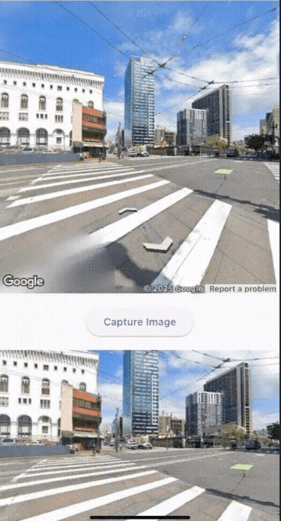
flutter_screenshot_google_street_view
👍 1 ⬇️ 42
Dart 3 compatibleMaintenance Status: Good
A Flutter package for capturing Google Street View screenshots
latlong
👍 117 ⬇️ 238
Maintenance Status: Poor
Lightweight library for common latitude and longitude calculation
polymaker
👍 54 ⬇️ 62
Maintenance Status: Poor
Polymaker is a flutter package used to get a list of locations for polygon google maps
polyline_do
👍 28 ⬇️ 156
Maintenance Status: Poor
Polyline encoding algorithm for encoding and decoding a list of coordinates
google_map_polyutil
👍 26 ⬇️ 33
Maintenance Status: Poor
Dart implementation of native google map utility class PolyUtil